Видеоуроки:
тематическая обработка
Наши видеоуроки помогут научиться применять
программный комплекс IMC на практике для решения тематических задач
Тематическая обработка
Урок 1. Сравнительный анализ участков подтопления на примере паводка в Уссурийском городском округе
11:11Урок по тематической обработке данных ДЗЗ, полученных со спутника Santinel-2 в ПО Image Media Center.
Для данной работы были взяты 2 снимка из открытого источника Earth Explorer (актуальный и архивный), а далее эти снимки открыты в программе через паспорт снимка. После произведена тематическая обработка по нахождению индекса NDWI, а далее полученные результаты индексных изображений переведены в векторные слои, в результате чего был выявлен класс воды. Далее было произведено сравнение между собой результатов 2х снимках с полученными векторными слоями воды. В конце работы все данные были занесены в таблицу атрибутов.
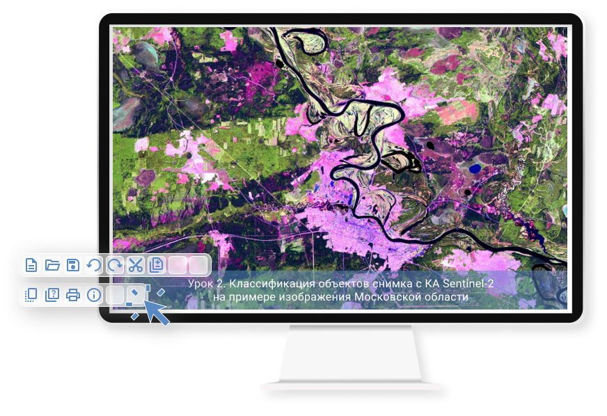
Урок 2. Классификация объектов снимка с КА Sentinel-2 на примере изображения Московской области
13:36Урок по тематической обработке данных ДЗЗ в программном обеспечении Image Media Center. Ход работы представлен в виде следующих этапов:
- открытия паспорта снимка;
- загрузки границ МО в формате shp;
- обрезке снимка по векторной границе карты МО;
- выделения классов (создания эталонов);
- Классификации методом наименьшего расстояния;
- работы с атрибутивной информацией.
Урок 3. Работа с макросом. Часть 1 - Организация рабочего пространства перед записью макроса в ПО IMC
3:56Урок по организации рабочего пространства перед записью макроса в ПО Image Media Center
Урок 4. Работа с макросом. Часть 2 -Создание макроса Классификация объектов местности(КА Sentinel-2)
13:562 часть урока по Созданию макроса по Классификации объектов на местности.
Урок 5. Мониторинг лесных пожаров на примере снимка с КА Landsat-8
12:36Урок по тематической обработке снимка с КА Landsat-8 в ПК Image Media Center включающий в себя такие этапы как:
- открытие паспорта снимка;
- атмосферную коррекцию;
- выделение неинформативных полей;
- настройки видимости тепловых каналов;
- создания канала с индексом нахождения участков с открытым огнем;
- нахождения значений в «Коррекции пикселов»;
- работы с «Цветовым рядом»;
- векторизацией полученных результатов;
- выбора стиля полигона;
- работы с атрибутивными данными;
- создание границ очагов пожаров.
Урок 6. Построение температурной карты с применением готового макроса
7:09Урок по работе с макросами в ПО Image Media Center на примере Москвы и Московской Области снимка с КА Landsat 8. Подробное описание этапов работ производимых макросом в автоматическом режиме с автоматическим созданием отчёта и температурной карты.
Урок 7. Сравнительный анализ температурных карт с использованием готового макроса в ПО IMC
9:01Урок по построению и сравнительному анализу на основе 10 температурных карт относящихся к территории Москвы и Московской Области с использованием готового макроса в ПО Image Media Center.
Урок 8. Мониторинг изменений растительного покрова на примере разновременных снимков Москвы и МО
11:58Урок по тематической обработке - Мониторинг изменений растительного покрова на примере разновременных снимков Москвы и МО с КА Landsat 8 и разбор таких этапов работы как:
- открытие паспортов для 2х снимков;
- атмосферная коррекция;
- работа с неинформативными полями;
- тематическая обработка (нахождение вегетационного индекса для растительности);
- сравнение 2х индексных слоев;
- работа с инструментом «выделить цветовой диапазон»;
- преобразование векторного слоя в отметки;
- работа с атрибутивной информацией;
- сортировка мелких объектов с помощью SQL запроса;
- сохранение полученных результатов.
Урок 9. Мониторинг вырубок леса на примере территории Республики Беларусь
6:55Урок по тематической обработке разновременных снимков с КА Sentinel-2 на примере территории Республики Беларусь в ПО Image Media Center
- открытие паспортов снимков;
- создание канала по формуле вегетационного индекса для 2х снимков;
- нахождение разницы 2х индексных слоев;
- загрузка shp файла с границами леса;
- нахождение значений точек в «Коррекции пикселов»;
- работа в «Цветовом ряде» с количеством классов;
- векторизация полученных слоев;
- работа с атрибутивной информацией;
- сортировка мелких объектов с помощью SQL -запроса;
- упорядочение оставшихся значений;
- выбор стиля полученных полигонов.
Урок 10. Обзор функции панхроматического слияния (Паншарпенинг) на примере снимков с КА Канопус В
9:06Обзорный урок по улучшению качества снимков с КА Канопус В, включающий в себя:
- ототрансформацию;
- геопривязку;
- создание композита;
- паншарпенинг.
Урок 11. Мониторинг ледовой обстановки. Выявление льда на примере снимка с КА Landsat-8
12:02Урок по тематической обработке снимка с КА Landsat-8, на котором рассматривается 2 способа выделения льда: формулой и готовым алгоритмом.
Работа состоит из таких этапов как:
- открытие паспорта снимка;
- создания векторного слоя с границами снимка и загрузки векторной карты морей;
- пространственного анализа;
- создания векторной границы моря;
- редактирования изображения с помощью гистограммы;
- создания снежного индекса (для обнаружения снега на земной поверхности);
- нахождения необходимых значений в таблице «Коррекция пикселов»;
- разделения на классы с помощью «Цветового ряда»;
- векторизации полученных слоев;
- работе с атрибутивной информацией.
Урок 12. Обзор модуля Каталогизация
6:02Обзор модуля Каталогизации в ПО Image Media Center, которая предназначена для хранения и управления большими объемами данных. В данном уроке рассмотрен процесс создания рабочего файла, добавления маршрутов и базы маршрутов. А так же работа с атрибутивной информацией.
Урок 13. Функция мозаика. Формирование бесшовной мозаики в IMC
8:00Так как исходные маршруты могут отличаться по цвету, геопривязке, и линейному разрешению на местности. Данный инструмент позволяет уточнить геопривязку для всех маршрутов, производит цветокоррекцию и проводит границу между маршрутами таким образом, чтобы она была незаметной.
В этом уроке будет рассмотрен пример формирования бесшовной мозаики из нескольких снимков с космического аппарата Landsat-8.
Урок 14. Геокодирование в IMC на примере снимка с КА Канопус В
8:18Обзор функции геопривязки ( геокодирования ) в ПК Image Media Center. В данном видеоуроке будут рассмотрены такие этапы работы как:
- открытие снимка Канопус В;
- подключение Google карт;
- добавление снимка Sentinel;
- открытие и работа в таблице геокодирования;
- обзор функции «Автоматический коррелятор» для растровых снимков;
- ручной набор опорных точек по снимку и Google картам;
- разбор геокодирования
Урок 15. Создание отчёта в ПК Image Media Center
14:54Для комплексной оценки результатов тематической обработки в ПК IMC реализована возможность формирования отчетов, которые могут содержать: снимки, тематические карты, легенду, графики, диаграммы и т.д.
В данном уроке как раз будет отображена вся информация по их созданию и редактированию.
Урок 16. Написание макроса границ снимка для функции Каталогизация
11:54Создание макроса для оптимизации работы с функцией Каталогизации в ПК Imsge Media Center состоит из:
- открытия файлов в формате tiff;
- открытия панели «Операции»;
- создания макроса (переменных, атрибутивной информации, открытия снимка, открытия shp файла)
- сохранение макроса;
- проверки созданного макроса;
- загрузки результатов в Каталогизацию.
Урок 17. Выявление леса на радарном снимке с КА Sentinel-1
7:44В данном уроке будет рассмотрен вариант ручной обработки радарных снимков таких входных данных как с КА Sentinel-1 в ПК Image Media Center:
- открытие радиолокационного снимка через меню Радиолокация;
- диапазон значений пикселов;
- кадрирование;
- подключение Google карт;
- устранение шумов;
- геокодирование (геопривязка);
- классификация изображения методом наименьшего расстояния
Урок 18. Картографирование территорий с использованием данных ДЗЗ в ПК Image Media Center
10:22В данном уроке будут рассмотрены Предварительная и Тематическая обработка для снимка с КА Landsat-8. А так же работа с векторными данными в которую входят:
- открытие паспорта снимка;
- атмосферная коррекция;
- кадрирование;
- создание нового канала;
- поиска индекса растительного покрова;
- цветовой ряд;
- векторизация полученных слоев;
- загрузка доп. векторных слоев;
- подбор стиля для каждого полигона.
Урок 19. Спектральный анализ данных ДЗЗ в IMC
8:45Обзор функции Спектральный анализ в ПО Image Media Center на примере снимка КА Sentinel-2. Работа будет происходить по следующим этапам:
- открытие паспорта снимка;
- спектральный анализ;
- получение спектральных графиков;
- выделение цветового диапазона;
- преобразование в вектор;
- сохранение и открытие полученных эталонов.
Урок 20. Обработка и нахождение термоточек на снимке с КА FengYun-3D
6:33Открытие, обработка снимка с КА FY-3D и поиск термоточек в ПК Image Media Center включает в себя:
- открытие файла HDF;
- получение спектрального среза;
- обработка материалов (получение пожарной продукции);
- получение растрового изображения с эффектом бабочки;
- удаление геометрических искажений;
- геометрическая коррекция (получение синтетического изображения);
- поиск термоточек;
- геотрансформирование;
- просмотр информации по термоточкам в таблице атрибутов.
Урок 21. Оценка линейного разрешения (оптика) в IMC
6:08Оценка линейного разрешения (оптика) в ПК Image Media Center на примере снимка с КА Канопус В состоящая из:
- открытия паспорта снимка;
- настройки диапазона значений пикселов;
- кадрирования;
- оценки качества (создания слоя с тест-объектами, нахождение резкого края);
- удаления отбракованных тест-объектов;
- альтернативного нахождения резкого края в ручном режиме;
- просмотра и сохранения отчёта.
Урок 22. Текстурный анализ данных ДЗЗ в IMC
6:47Обзор тематической обработки данных ДЗЗ в ПК Image Media Center состоящий из:
- открытия паспорта снимка;
- настройки яркости изображения;
- кадрирования изображения;
- редактирование размера изображения;
- проведения текстурного анализа (создание, сравнение и сохранение эталонов текстур);
- коррекция пикселей;
- устранение шумов;
- векторизации;
- цветового ряда;
- сохранения документа.
Урок 23. Классификация морских льдов по радарному снимку
10:03Урок по тематической обработке (классификации льда) на радарном снимке Sentinel 1 в ПК Image Media Center
Урок 24. Детектирование судов по радарному снимку
9:14Подробный урок по нахождению судов на радарном снимке на примере снимка КА Sentinel-1.
Урок 25. Поиск нефтезагрязнений по снимку Sentinel-2
10:26Урок по тематической обработке снимка с КА Sentinel-2 - нахождение и идентификация нефтезагрязнений.
Урок 26. Мониторинг земель сельскохозяйственного назначения на разновременных снимках lANDSAT-8
11:24Урок 26. Мониторинг земель сельскохозяйственного назначения на разновременных снимках lANDSAT-8
Урок 27. Моделирование распространения лесных пожаров в Амурской области (снимок Landsat-8)
12:54Урок 27. Моделирование распространения лесных пожаров в Амурской области (снимок Landsat-8)
Урок 28. Моделирование наводнений в Уссурийском районе
07:18Урок по тематической обработке в ПК IMC, в котором рассматривается процесс моделирования наводнения с ЦМР на Уссурийский район. В качестве подложки использован снимок с КА Landsat-8.